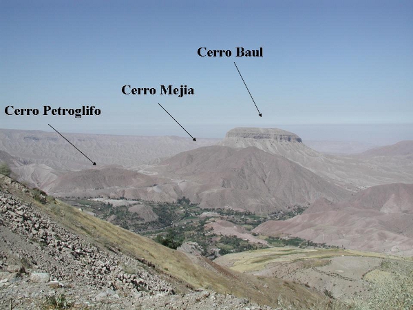
There are a number of Wari settlements located in the Moquegua Valley. Cerro Baul resembles Wari sites in other parts of the Andes the most and exhibits monumental architecture. Cerro Baul is located on a prominent mesa feature. Cerro Mejia, an adjacent hill also has some structures that resemble Wari architectural canons, however the majority of buildings take other forms and many are rather humble terrace dwellins on the hill’s southern slope facing Cerro Baul. Cerro Petroglifo also exhibits some similarities to Wari architecture, however the site was never finished, and appears never to have been occupied. It seems to have been a planned community. One that would be built all at once rather than developing slowly from a few houses to a larger community overtime. For some reason the project was halted leaving different parts of the site in different phases of construction. It is somewhat of a mystery that Wari affiliated populations never used it, it is more of puzzle to understadn why no group that followed also chose not to live at the site.
Cerro Mejia
Cerro Mejia, the largest Wari residential settlement in the Moquegua colony, is located adjacent to Cerro Baúl and is surrounded by agricultural fields. The site has residential structures of several kinds, production areas, ceremonial areas, and public structures. The residential areas are divided by large walls into segments of some kind. Given variations in vessel form between houses these spatial divisions may relate to significant social differences, but a larger sample is needed to understand the potential pluralities. I consider Cerro Mejia a tertiary center because evidence of large scale public spaces and residential administrative facilities in the houses of elites on the summit were large enough to accommodate the regional population and not just the people living at Cerro Mejia.
There are two primary zones of residential occupation, the summit of the hill and the terraced southeastern slope facing Cerro Baúl. An irrigation canal runs along the southeastern slope and divides the majority of residences from the agricultural fields below. Along the canal at the base of all the barrios there is a public processing zone with many grinding stones, massive batanés with their manos still close at hand. The canal divides in this area. One branch continues along the slope of Cerro Mejia, and the other crossed over an aquaduct to the slope of Cerro Baúl. Near this canal division there is a low plateau with special buildings in which we found intense fire features and what we believe to be slag. The area seems to have been used to fire ceramic vessels or to refine copper ore. The large batans and manos in this zone could have been used for grinding copper ore, clay or tempering material and require chemical testing to assess their productive role.
Also in this area just upslope from the plateau, wide monumental stairs ascend the hill slope and provide access between the summit of Cerro Mejia and Cerro Baúl. South of the workshops on a lower spur there is a complex of plazas known as El Paso. These plazas are a later construction, however, they and the earlier structures in this zone were associated with ritual practices. Around on the northeastern slope facing Cerro Petroglifo there are a few clusters of structures just above the canal that may also be residential but were not tested.
The summit of Cerro Mejia is bound by seven thick wall segments, which are located along the steepest drop offs in the terrain. The summit architecture is nearly monumental in nature. The majority of the structures are large residential clusters. Some of these structures exhibit elaborated architecture that suggests they may have housed groups of elevated status. In the summit’s center there is a large platform and plaza complex that served as the stage for public ceremony and administration. The complex includes two platforms one to the north and one to the south, the platforms face westerly in direction. Smaller platforms are located along the north side of the open space. These structures may have played a role in some form of dual administrative organization or ceremonial practice. Perhaps the people in the colony were divided into two or four political groups.
The domestic terraces of the hill’s southeastern slope are divided by large walls, which run along quebradas, into six segments or barrios. Barrio 1 on the eastern extent of the southern slope exhibits very large monumental structures that may not be residential. This area was not tested because the walls were made of megalithic stones, many of which had toppled and covered large portions of floor surfaces. Barrio 2 contained residential Unit 3 and the monumental stairs leading to the summit. Barrio 3 contained residential Unit 4 and along its western boundary wall there is a modest stairway to facilitate access to upslope houses, but it does not reach the summit. Barrio 4 could possibly represent two barrios, but is divided by a deep quebrada rather than a wall. Barrio 4A contained residential Units 5 and 6. Barrio 4B contains many low mounds that I suspected might be houses built with different construction materials. Unit 7, a small probe in one such mound contained domestic artifacts, but no clear use surface. Barrio 5 was not selected for testing because the remains were covered by large piles of rocks suggesting the buildings may have had high walls or multiple stories. Barrio 6 exhibited the sparsest concentration of residential settlement, probably as a result of the steep nature of the hill in this area.
